In line with the new Google Maps update, one of those essential apps quickly comes to mind that the big G has been inspired by to add mixed trips. Yeah, Citymapper has had them for some time, so it is the perfect time to make this app stand out with more than 5 million downloads, an average score of 4,5 and 66.668 reviews to date.
Una Essential app for city dwellers in order to easily move around cities such as Madrid and Barcelona by combining all means of transport, and thus finding the best route. That is, it will use the data from the metro, Renfe trains, buses, Uber / taxi, Car2go and bicycles. An app of those that when you try it, you will not be able to stop using it; as long as you live in a big city ...
An app for urbanites
In Spain we have cities with the best public transport systems around the world. Madrid itself has a tremendously efficient metro network that allows you to be in a matter of minutes from one end of the city to another.
But if we know how to use that public transport better, we must not forget the enormous number of bus lines or that network of trains that cross the city with different lines, in combination as an app like Citymapper, especially for those who arrive outside of the city, we will have the best ally to move like tadpoles through a city of enormous dimensions like Madrid itself.
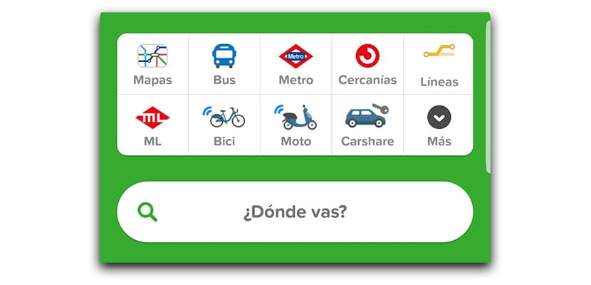
El Citymapper algorithm will collect data from all these services:
- Metro Madrid and Metro Barcelona
- Renfe trains
- Bus Madrid (EMT) and Bus Barcelona (TMB)
- Uber and Taxi.
- Car2Go
- Bicing bikes
- Bicimad
- Walking routes.
That algorithm will be in charge of updating daily trips with new data and will even be able to tell you where to put you on the platform to oppress the trip (if you know the Madrid metro you will know that getting downtown is a bit crazy at certain times), recommend a metro exit, the possibility of easily sharing with WhatsApp and more app or offer you a complete planner for Android Wear with step-by-step instructions.
Already in Citymapper
Since we open the app, we will find ourselves on the main screen with a map at the top, direct access to all the transport possibilities we have, an action button to indicate where we are going and the possibility of defining both our home and our work. We can also add a shortcut from the icon itself to "go" to a place from the desktop.
If we say that we are going to Puerta del Sol, a preview will appear with the direct route. We just have to click on the green "go" button, so that the different routes appear. First on a card, We found the time it would take to walk, in bike, in the Car2Go rental car service or in Uber. Data such as the calories we will consume are also added here.
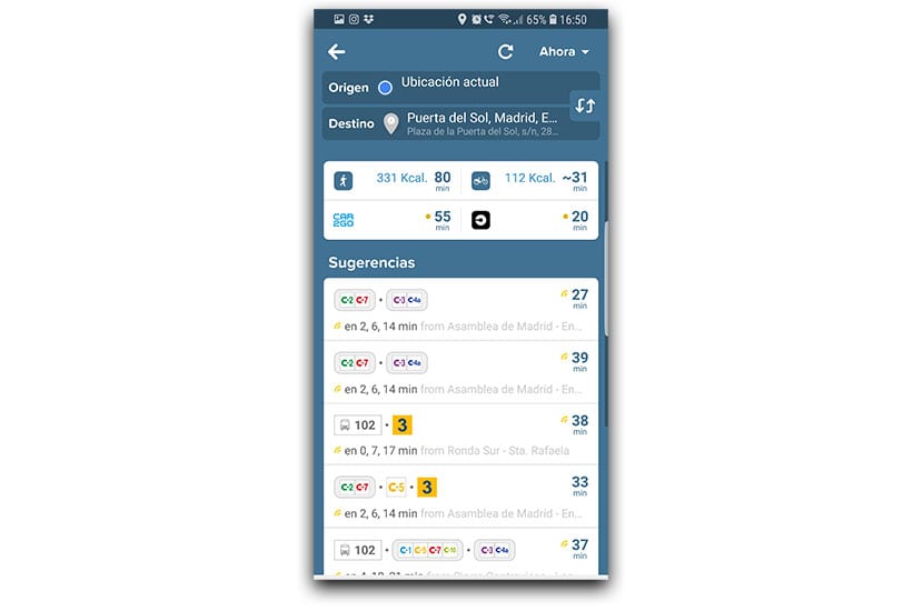
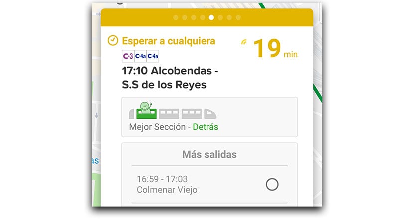
Just below we have the card with the suggestions. The fastest one appears in the foreground. In our case would take two train lines to arrive in 25 minutes to Puerta del Sol. Just below we find alternative routes with their approximate arrival times. Just like we can choose to go by bus only if we wish.
Already en route
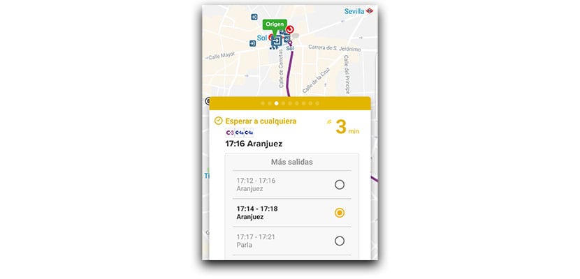
Once the route is selected, the entire itinerary will appear until we reach our destination. We will see in different colors the different train lines that we will take. In this case, as we take two different lines, one appears in green and the other in purple.
We give to go, and we will begin the route. We can move the cards so that the magic of Citymapper appears: they will indicate the next train arrivals. In this case it would be one that goes to Chamartín and would pass between 17:05 and 17:09. Enough time while we walk to the station. We can select any of the departures, although the trip would be updated.
Another of the best points of Citymapper is that we can see the schematic drawing of the train in which it is indicated which is the best section to avoid being tight. On the trip from Atocha to Sol they recommend the car behind us, so go ahead!
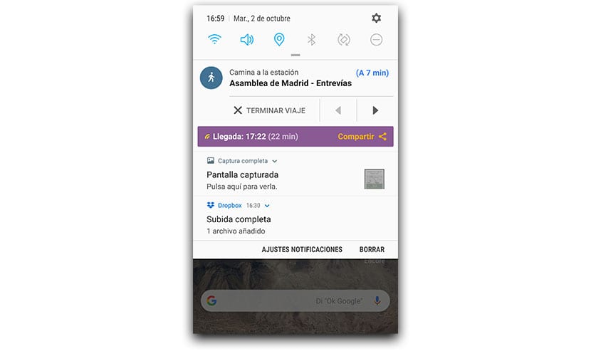
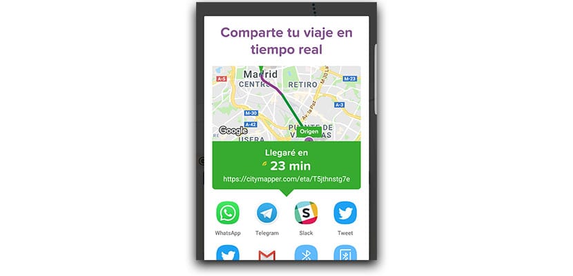
Finally we will make our way on foot. We also have the option to follow the entire trip from the notification panel in which we are briefly informed with the most important data of the route. That is, walk to the station, destination, time, arrival time and even the possibility of sharing it with any friend. This way you can let him know how long he has left to get to the meeting or appointment.
Ultimately, Citymapper is a great must-have app for urbanites and that allows us to get all the juice out of cities like Madrid and Barcelona when it comes to moving around. Google Maps has arrived, but something tells us that this app will continue to be very much alive among thousands of users.